Allan Wise
Introduction
Regarded as Tasmania's premier day walk, Mt Anne attracts experienced bushwalkers for three main reason. One, amazing scenery and great photo opportunities. Two, It's subjected to absolutely foul weather conditions and intense exposure. And Three, The final ascent is very steep, making it hard in the best of times and almost impossible when icy or snowy. Ropes may help at the summit, most confident climbers will find it manageable.
Access
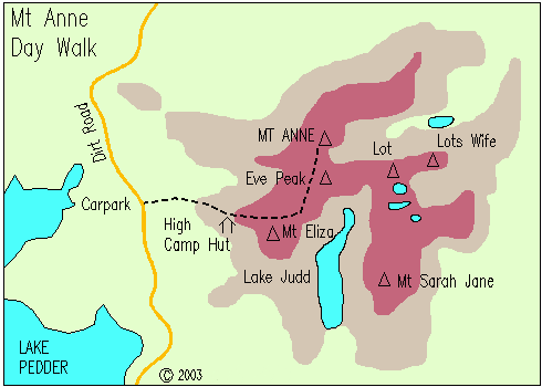
A permit is required for travel in any of Tasmania's national parks. Permits can be purchased from most outdoor shops or on entry to the national park. There is a Toll booth just out of Maydena, the gateway to the south west. About 19.3 km from there - along Scotts Peak Road - is Condominium Creek, the start of the walk. At the start of the walk there is a car park, camp area, toilet, and walker registration booth.
High Camp Hut - 1 to 1.5 hours medium walking
From the car park, walk east along a track that is mostly duckboard for 400m. There is an abrupt start of the climbing spur. The climb is 3.6 km in length and rises 600m. Here there is a hut in a patch of small trees know as High Camp Hut. The toilet has a window and faces north overlooking lake Pedder. It has become know as "the loo with the view". The hut walk is a good day walk in it self. well worth the trip if you are not keen to climb all the way to the summit.
Hut to Mt Eliza - 1/2 to 1 hour medium climbing
From High Camp hut it is a slow ascent to reach the Mt Eliza plateau. the track rises rapidly nearly reaching 45 degrees. Small rock cairns (a pile of rocks) define the easiest route. The route leads directly to Mt Eliza, 300m elevation from the hut and 1289m above sea level. Mt Eliza is rated 2 peak-bagging points.
Mt Eliza to Anne circuit track junction - 45 mins easy walking
Heading in a north-easterly direction the track is basically flat and follows the ridge to the base of Mt Anne. There is a number of small rises and some boulder hopping. There are plenty of tarns, where you can refill water bottles. It is quite exposed to the elements along the ridge, It is a good indication if you are having trouble here that you are unlikely to summit Anne on this trip. The Circuit track junction is just past a very large unnamed crop of rocks and just before a largish rock jutting out of the plateau. This rock provides some wind shelter, good if you are waiting for friends. The Circuit track heads down into the valley to your right.
Circuit track junction to Mt Anne summit - 1 to 2 hours hard walking/climbing
Traveling a short distance we reach the boulder-covered slopes of Mt Anne. Cairns show the access route up. Through an absolute chaos of rocks the awe-inspiring summit block of Mt Anne towers above you. The last section is quite tricky, ropes may help those not totally confident in there free climbing abilities. The summit on a clear day has a panoramic view of virtually all south-west Tasmania. You are surrounded by a plethora of jagged ranges, lakes and button grass ranges. There is a log book at the top.